Other Case Studies
The SMART partnership supports improved law enforcement and biological monitoring in protected areas around the world. They came to Refractions to build a software tool to help meet their needs.
Hectares BC – Biodiversity BC on behalf of a broad partnership
Biodiversity BC and its government and non-government partners were looking for regional-level environmental statistics. Refractions proposed a new approach to generating GIS summaries, using the power of a relational database and web tools to provide GIS analysis to users who previously had no access to it.
Automated Route Planning for Meter Reading – City of Vancouver
The City of Vancouver collects water readings from thousands of residences and businesses, but has never optimized the pedestrian routes the readers take. Refractions developed algorithms to create the most efficient routes of the correct length for readers.
Digital Road Atlas – BC Integrated Land Management Bureau
Refractions provides full-service support for the British Columbia Digital Roads Atlas – systems design, maintenance, data conflation, client service, and rapid response.
Caribou Habitat Assessment and Supply Estimator – Wildlife Infometrics Inc.
Refractions converted a legacy habitat modelling system based on ArcView 3.X to ArcGIS 9.2, and automated the workflow to provide faster turnaround time for model runs.
Line Cleaner – BC Ministry of Forests
The British Columbia Ministry of Forests needed a tool to conflate multiple roads databases into a single working layer. Refractions delivered the algorithms and a user interface based on the uDig platform.
Interest Reports – BC Ministry of Agriculture & Lands
Refractions developed an ArcMap extension to automate the calculation of standard reports joining a massive shape-file archive with a large Oracle database.
Mobile GIS – UN Food & Agriculture Organization
UN FAO needed a data collection tool that could run disconnected and didn't have a per-seat licensing cost. Refractions delivered a simple tool using the uDig desktop platform.
Open Web Services, Phase 3 – Open Geospatial Consortium
The Open Geospatial Consortium runs regular “testbed” projects to field-test new concepts in geospatial interoperability. Refractions was a part of the OWS-3 initiative, and built a uDig-based “GeoDSS” client to provide access to several other OGC standard services, including a prototype GeoVideo service.
Natural Language Spatial Search Engine for Rental Places-Rento
Rento is a free web service that makes it easy to find a place to rent in Greece. Powered by PostgreSQL and PostGIS, it provides ad listings with photographs displayed on a map. Searching is accomplished through map navigation and natural language processing, with the search engine being capable of answering complex (spatial) questions such as "flat near the University of Athens" or "loft up to 800 euros near a metro station" (in greek).
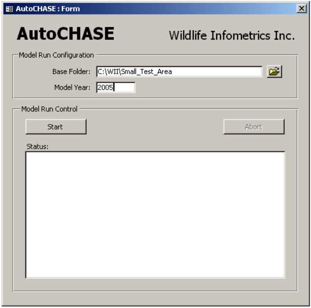
Caribou Habitat Assessment and Supply Estimator (CHASE) – Wildlife Infometrics Inc.
Our Client
Wildlife Infometrics Inc.
September 2006 - December 2006
http://www.wildlifeinfometrics.com/
Project Background
Declines in caribou herd populations throughout British Columbia (BC) are the result of many factors including: global climate change, habitat modification from resource development, displacement by human activity, and increased mortality. Recently, predation by wolves has had the most serious effect on herd populations – especially of those in southern BC. Many of these herds now number fewer than 50 animals.
Wildlife Infometrics Incorporated (WII) in MacKenzie, BC maintains CHASE – a caribou habitat supply modeling tool. CHASE has assisted planners in government and industry with the management of habitat for woodland caribou for many years and has been applied to identify winter ranges of legal status and to aid decisions about recovery of local herds. CHASE is comprised of several disparate components: ArcView 3, Norsys Netica and Microsoft Access. Until now, each application of CHASE has required trained technicians to perform time-consuming and repetitive procedures to generate habitat results for summary.
WII sought Refractions' expertise in spatial systems design and Visual Basic for Applications (VBA) programming in ESRI's ArcObjects to consolidate CHASE's complicated workflow into an easy-to-use application controlled from a user-friendly dashboard.
Refractions' Solution
The client's primary interest was that the new software be compatible with their upcoming migration to ESRI's ArcGIS 9.2 (from 9.1). With this in mind, Refractions proposed an ESRI ArcGIS/ArcObjects solution to replace the existing workflow based largely on ArcView 3.2 and AVENUE.
It was important that the new system produce exactly the same results as the original system, so we ensured we had lots of information for quality control:
- We collected inputs, intermediate results, and outputs from the existing model.
- We compared the results at each step when debugging the new system.
- We ensured that the final deliverable produced the same results as the original system.
Converting from ArcView 3.X to ArcGIS 9.2 required a complete re-write of all the GIS processing routines, from originals in Avenue to the new code in ArcObjects/VBA. Some of the routines in ArcObjects did not have exact analogues to the original Avenue routines, and had to be carefully matched to new functions in the ESRI API and tested for consistency with the old routines.
The Result
AUTO-CHASE provides a central, graphical user-interface (GUI)-driven platform from which to specify parameters for and run CHASE modeling operations. The application interface requires limited user-input and handles all intermediate data and model output locations internally. Final outputs are identical in schema and format to the previous version (CHASE).
Client Benefits
The automation of AUTOCHASE allows broader use of WII's caribou habitat assessment and supply estimator models, through:
- An expanded user pool given the simpler implementation, and
- Greater efficiency and decreased potential for error given reduced user contact time
The end result allows WII to provided it's clients with the capability to monitor caribou habitat faster and at lower costs than before.