Other Case Studies
The SMART partnership supports improved law enforcement and biological monitoring in protected areas around the world. They came to Refractions to build a software tool to help meet their needs.
Hectares BC – Biodiversity BC on behalf of a broad partnership
Biodiversity BC and its government and non-government partners were looking for regional-level environmental statistics. Refractions proposed a new approach to generating GIS summaries, using the power of a relational database and web tools to provide GIS analysis to users who previously had no access to it.
Automated Route Planning for Meter Reading – City of Vancouver
The City of Vancouver collects water readings from thousands of residences and businesses, but has never optimized the pedestrian routes the readers take. Refractions developed algorithms to create the most efficient routes of the correct length for readers.
Digital Road Atlas – BC Integrated Land Management Bureau
Refractions provides full-service support for the British Columbia Digital Roads Atlas – systems design, maintenance, data conflation, client service, and rapid response.
Caribou Habitat Assessment and Supply Estimator – Wildlife Infometrics Inc.
Refractions converted a legacy habitat modelling system based on ArcView 3.X to ArcGIS 9.2, and automated the workflow to provide faster turnaround time for model runs.
Line Cleaner – BC Ministry of Forests
The British Columbia Ministry of Forests needed a tool to conflate multiple roads databases into a single working layer. Refractions delivered the algorithms and a user interface based on the uDig platform.
Interest Reports – BC Ministry of Agriculture & Lands
Refractions developed an ArcMap extension to automate the calculation of standard reports joining a massive shape-file archive with a large Oracle database.
Mobile GIS – UN Food & Agriculture Organization
UN FAO needed a data collection tool that could run disconnected and didn't have a per-seat licensing cost. Refractions delivered a simple tool using the uDig desktop platform.
Open Web Services, Phase 3 – Open Geospatial Consortium
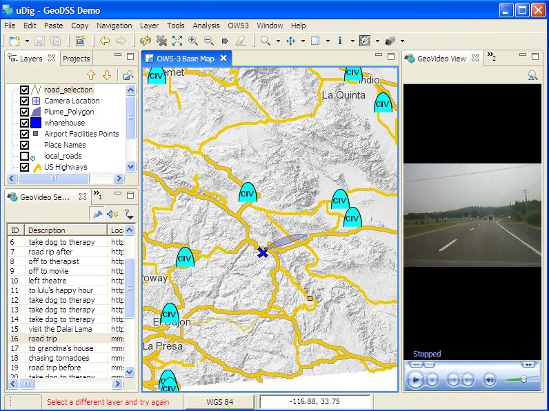
The Open Geospatial Consortium runs regular “testbed” projects to field-test new concepts in geospatial interoperability. Refractions was a part of the OWS-3 initiative, and built a uDig-based “GeoDSS” client to provide access to several other OGC standard services, including a prototype GeoVideo service.
Natural Language Spatial Search Engine for Rental Places-Rento
Rento is a free web service that makes it easy to find a place to rent in Greece. Powered by PostgreSQL and PostGIS, it provides ad listings with photographs displayed on a map. Searching is accomplished through map navigation and natural language processing, with the search engine being capable of answering complex (spatial) questions such as "flat near the University of Athens" or "loft up to 800 euros near a metro station" (in greek).
OGC Web Services, Phase 3 – Open Geospatial Consortium
![]() The Open Geospatial Consortium is an international industry consortium of over 300 companies, government agencies and universities participating in a consensus process to develop publicly available interface specifications. OpenGIS®® Specifications support interoperable solutions that “geo-enable” the Web, wireless and location-based services, and mainstream IT. The specifications empower technology developers to make complex spatial information and services accessible and useful with all kinds of applications.
The Open Geospatial Consortium is an international industry consortium of over 300 companies, government agencies and universities participating in a consensus process to develop publicly available interface specifications. OpenGIS®® Specifications support interoperable solutions that “geo-enable” the Web, wireless and location-based services, and mainstream IT. The specifications empower technology developers to make complex spatial information and services accessible and useful with all kinds of applications.
As part of the standards development process, the OGC hosts annual interoperability projects, sponsored by major governments and corporations from around the world. In 2005, the “OGC Web Services, Phase 3” (OWS-3) project brought together dozens of companies to develop new standards for interoperability.
Refractions was selected by the OGC to provide the “Geographic Decision Support System” (GeoDSS) component of the project, using our open source uDig open source application framework. The GeoDSS component was the piece of software that would be highly visible for OWS-3 – many of the other components were server-based and would be visible only through the mediation of the GeoDSS client.
The Refractions GeoDSS client supported to following aspects of OWS-3:
- Development and demonstrating a GeoVideo client/server pairing (using a Geovideo server developed by Intergraph).
- Demonstration of catalogue search.
- Demonstration of Web Feature Service client.
- Demonstration of Web Map Server client.
The Refractions team delivered a uDig GeoDSS system to the OWS-3 demonstration in Washington DC at the end of the project, as well as Mapserver-based data publishing services that were extensively used in the final demonstration.