Other News
Sept 15, 2025
Mar 1, 2025
Sept 26, 2024
Aug 16, 2023
Apr 1, 2023
Aug 27, 2022
Refractions Releases “TerrainServer” 3D Web Mapping System
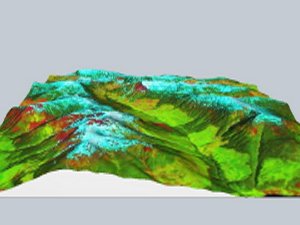
Refractions Research today announced the availability of "TerrainServer" 3D Web Mapping system to resellers and integrators. TerrainServer adds a third dimension to any ArcIMS or OpenGIS WMS map server, and delivers the results to users over the web in real time. Complete product information is available at the TerrainServer product site: http://www.refractions.net/terrainserver
"TerrainServer is a breakthrough tool in terms of ease of setup and integration with existing internet mapping infrastructures", says Paul Ramsey, president of Refractions Research. "A 2D mapping site can be made 3D by simply adding a single JavaScript button."
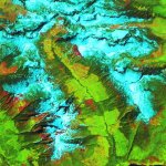
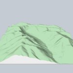
TerrainServer operates as an extension to existing web mapping technology. A 2D web mapping server creates a map, which is then draped on top of a 3D view created by TerrainServer. The result is a unique and informative hybrid of terrain and cartographic information.
| ||||||||
TerrainServer is available via different sales channels for different kinds of customers:
- Customers with one or a few ArcIMS services can subscribe to TerrainServer services via our partner Geocortex.net, who provide TerrainServer services under the trade name "Geocortex Perspective".
- Customers who want to resell TerrainServer services to their own clients under their own trade names should contact our business development staff.
- Customers who want to purchase TerrainServer for internal use as a complete integrated system (not a subscription service) should contact our technical appraisal staff for information on technology requirements and setup.